The DEAcube is the core of a new methodology to develop multi-hazard and multi-users risk scenarios from natural hazards, studied in a Master Thesis in A.Y. 2012-2013 as a new Task of DEA Project, in collaboration with CIMA Foundation and Vrije Universiteit Brussel – Department of Geography (DEAcubePoster).
Vector representation of reality
The global characterization of the territory can be imagined as a vector representation. According to this representation, the real world is scanned: each single object on the territory is seen not only composed by its physical structure but as an infinite series of informative layers, that are able to describe its features and its behaviours at three hundred and sixty degrees. This “stratified” description of the environment allow us to live in a sort of “hyper reality”, an amplified reality that contains all the possible levels of knowledge of the elements. This type of description is particularly useful when an object could be described differently considering different dimensions; these dimensions could be spatial, temporal or generically related to the final purpose of the user that is looking for a description of the territory.
Multi-users risk scenarios
Risk scenarios are useful tools that can be used for different purposes by different users inside the natural hazards risk management cycle. This field involves a big number of actors from different backgrounds. The first consequence is that these actors have different existing knowledge and are focused on a specific dimension of risk. That is the reason for which it is so important to develop a tool able to contain and elaborate together risk scenarios ad hoc for a lot of possible users.
Multi-user risk scenarios are scenarios built ad-hoc for different users’ needs. Which parameters can be identified to cover these different needs?
1)geographic scale: the territory can be studied at the scale of the single element for local studies till the global scale, in which the vulnerability is aggregated at big areal elements;
2)temporal scale: the risk can be assess in different phases of the territory management such as in emergency, in planning or in restoration activities ;
3)diversity of impacts: a certain element can be characterized in economic, environmental and social (human lives and civil protection) terms.
The DEA cube
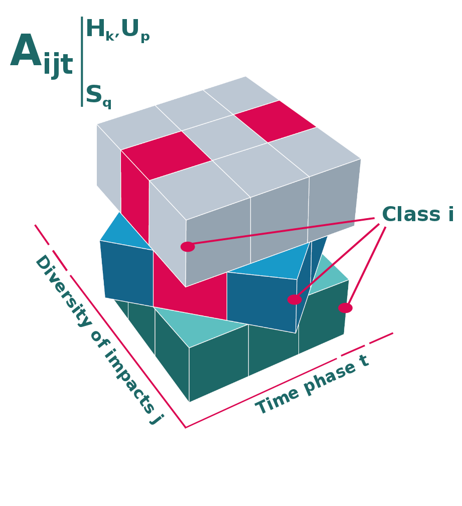
The vector representation of the space with the parameters introduced previously can be presented through a mathematical representation at six dimensions.
Let us consider a certain hazard Hk, where k=1,…,z are the different hazard that can be implemented in our model (i.e. flood, volcanic eruption, cyclon…) and a certain user Up, where p=1,…,w are the different users that can be implemented in the model (i.e. urban planner, civil protection agency…). A certain territorial element Aijt subject to a certain hazard and modelled for a certain user, conditioned to a certain geographic scale Sq, where q=1,…, v is the geographic scale (i.e. local, regional, national…), is univocally determined inside its reference system through the following three dimensions :
-the time phase t , with t=1,…,n that are the temporal phases (pre-cris, crisis, post crisis..)
-the diversity of impacts j, where j=1,…,m are the different impacts that can be considered (physical, social, economic, environmental…)
-the class of the element i, where i=1,…,r are the different classes of exposed elements (residential buildings, roads, parks…)
This representation is named DEAcube.
Each cell of the cube represent a possible description of the territorial element. In this type of representation the user can consider only one of the possible characterization of the territory (only one cell), all the characterizations or a variable number of cells.
