Digital Earth Action Task3 has been developed inside a Bachelor Thesis in Environmental Engineering at University of Genoa in 2011.
Inside this task, a methodology for the systemic vulnerability assessment of infrastructure networks subject to floods have been developed. In this approach the territorial system is modeled through the application of graph theory : roads, villages , buildings are the nodes of the graph while the edges are represented by their topographic connections. Since the arcs are links that do not take into account the topographical functional dependencies between the elements, this approach can also be applied in areas known only from remote observation.
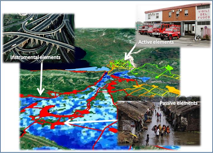
The relevant territorial elements are those that play a significant role in the emergency management:
- service providers with active roles in emergency management: hospitals, clinics, first aid, fire …
- subsystems which show a decrease in their functionality as a result of external stresses and require services from other sub-systems (schools, universities, residential areas or in general areas affected by a large influx of people);
- instrumental elements (roads, highways, railways …).
The information related to the network is organized in a database , which contains tables specific for each type of exposed element, inside which it is possible to collect all the available information.
The response of the network to the external stress is evaluated by applying an algorithm developed in literature by Minciardi et al.[i], modified to receive in input the residual function of each network element, that is function of the considered hydraulic scenario through damage curves. The algorithm provides as output a value of residual efficiency for the active and instrumental element and a value of criticality for the passive elements, analyzing the influence that each active node and instrumental exercises on the other nodes in the network.
[i] R. Minciardi, R. Sacile, A.C. Taramasso, E.Trasforini, S. Traverso., Modeling the vulnerability of complex territorial systems: An application to hydrological risk, Environmental Modeling & Software 21 (2006) 949-960.
